
Massive Spring Snowstorm: Over 2 Metres (6.5 Feet) of Fresh Powder Heading to European Alps
Published Date:

Melbourne-based skier and snowboarder with 50+ resorts across 5 continents. Specialises in Australian resorts and international resort comparisons.
Categories
Massive Spring Snowfall Set to Transform Alps with Over 2 Metres (6.5 Feet) of Fresh Powder
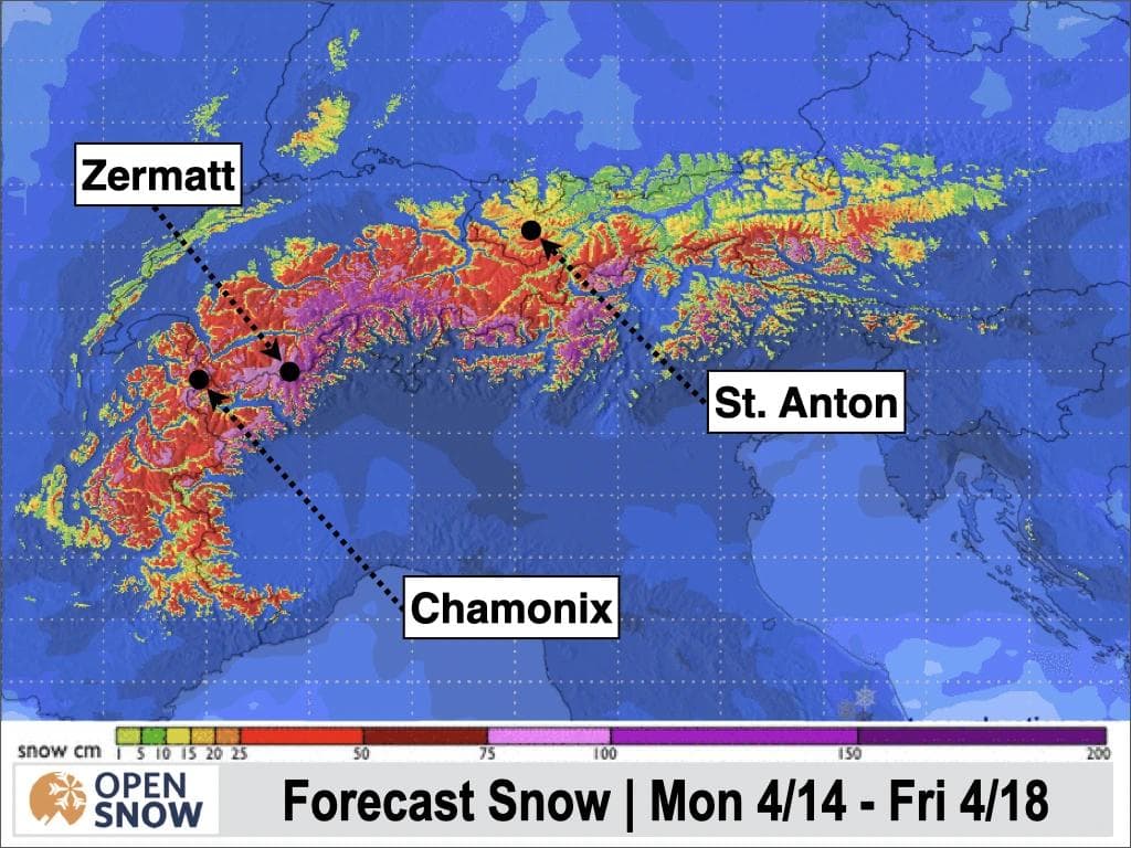
A powerful spring storm system is approaching the European Alps, promising a remarkable late-season refresh for high-elevation ski resorts. According to the latest forecast from meteorologist Luke Stone at OpenSnow, some areas could receive more than 2 metres (6.5 feet) of fresh powder over the next 10 days, creating outstanding late-season conditions across the region.
The storm will arrive in two waves, with the first system delivering heavy snowfall from Wednesday through Friday, followed by a potential second surge over the weekend. The heaviest accumulations are expected in the southern and western Alps, particularly in Switzerland and Italy, where some ski resorts could see over 1.5 metres (4.9 feet) from the first storm alone.
"A major storm is headed for the Alps this week, with the heaviest snow expected in the southern and western parts," reports Stone in his latest European Daily Snow forecast. "Winter is coming back to the upper elevations of the western and southern Alps."
While the first storm's trajectory is becoming clearer, snow levels remain somewhat uncertain. Forecasts suggest snow levels will initially hover around 2100-2400 metres (6,890-7,874 feet) through Wednesday morning before dropping to between 1400-1700 metres (4,593-5,577 feet) by Thursday, particularly in the western Alps. This means that while higher slopes will receive substantial powder, lower elevations may see rain or mixed precipitation.

The southern Alps in Italy and Switzerland will benefit most from the storm's orientation, with winds primarily from the south and southeast during the initial phase before shifting to north/northeast as the cold front moves through. This pattern favours southeast and south-facing areas initially, but will eventually deliver accumulations to western, northwestern, and northern slopes as well.
Zermatt in Switzerland stands out as the biggest winner, with forecasts showing potential for over 70 centimetres (28 inches) during the first wave alone. Val Thorens and Chamonix in France are also expected to receive significant accumulations. Higher elevated ski resorts in Valle d'Aosta (Italy), the Wallis region of Switzerland, and the Savoie region of France are positioned to receive the most substantial snowfall.
The timing of this storm creates both opportunities and challenges for skiers and riders. While the fresh powder will dramatically improve conditions, the April sun is strong, potentially affecting snow quality quickly after storms clear. Additionally, the heavy accumulations may temporarily limit terrain availability due to avalanche mitigation work, particularly on Thursday.
The Pyrenees will also benefit from this weather pattern, though with generally lower elevations than the Alps, snow quality there may be more variable. The best conditions will be found at upper elevations where colder temperatures will maintain snow quality.
Top 12 Resorts for Snowfall in the Next 10 Days
Based on combined forecasts for the next 10 days, these ski resorts are expected to receive the most significant snowfall totals:
- Gressoney-la-Trinite (Italy): 299cm (118 inches)
- Saas Fee (Switzerland): 274cm (108 inches)
- Macugnaga (Italy): 241cm (95 inches)
- Zermatt (Switzerland): 231cm (91 inches)
- Breuil-Cervinia (Italy): 221cm (87 inches)
- Saas Grund (Switzerland): 226cm (89 inches)
- Bonneval sur Arc (France): 208cm (82 inches)
- Riederalp - Aletsch (Switzerland): 172cm (68 inches)
- Val d'Isere (France): 173cm (68 inches)
- Alagna (Italy): 165cm (65 inches)
- Champoluc (Italy): 155cm (61 inches)
- Fiesch - Eggishorn - Aletsch (Switzerland): 160cm (63 inches)
For skiers and riders looking to catch this remarkable spring powder opportunity, the higher elevation resorts in the southern and western Alps clearly offer the best potential. While April storms can be unpredictable, the forecast confidence is high for significant accumulations across these regions, potentially delivering some of the best late-season conditions in years.