
How the West Lost Its Winter: The 2025-26 US Snow Drought Explained
Published Date:

Melbourne-based skier and snowboarder with 50+ resorts across 5 continents. Specialises in Australian resorts and international resort comparisons.

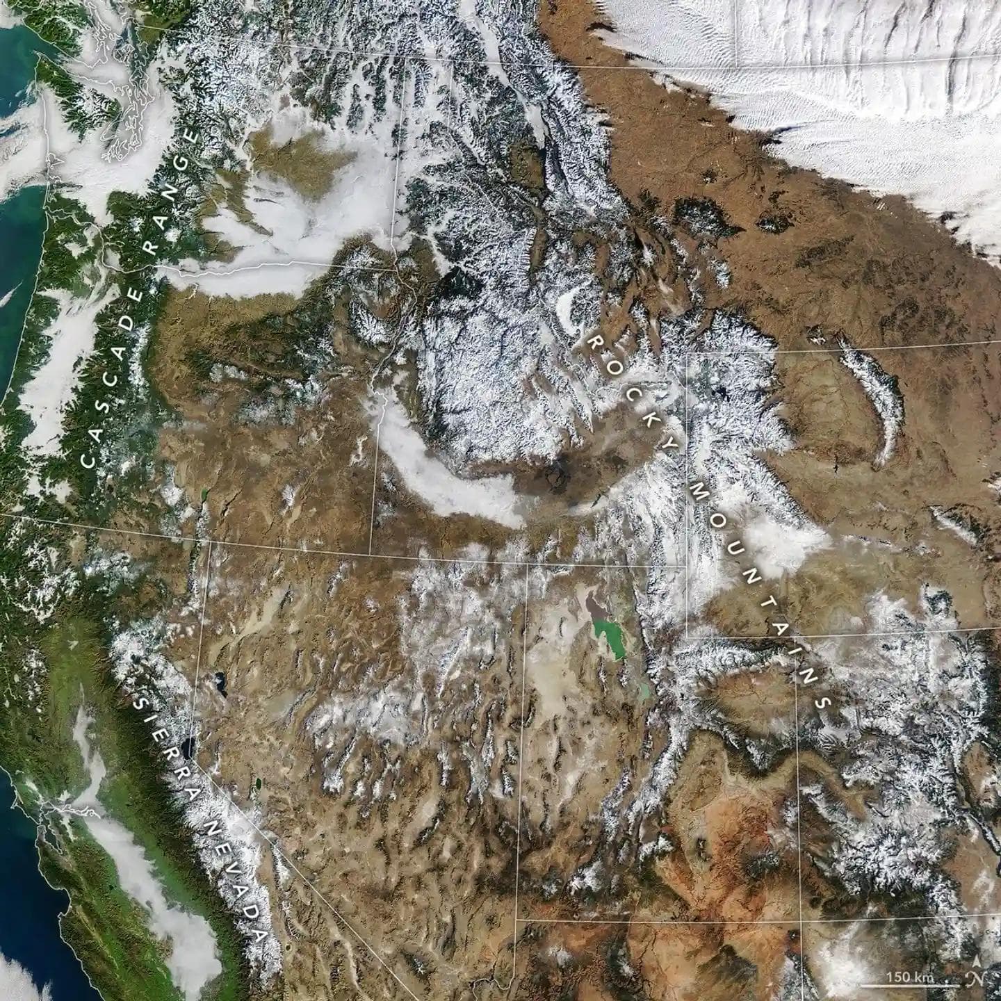
The 2025-26 western ski season wasn't just bad — it was the worst in recorded history, driven by a convergence of oceanic, atmospheric, and climatic forces that collectively dismantled snowpack across eight states. Record-low April 1 snowpack was set simultaneously in Arizona, Colorado, Idaho, Nevada, New Mexico, Oregon, Utah, and Wyoming, with California recording its second-lowest value. The culprits formed a reinforcing chain: a continent-sized marine heat wave in the North Pacific built a persistent high-pressure ridge over the West, the jet stream was shunted far north, temperatures ran 5–10°F above normal for months, and precipitation that did arrive fell as rain rather than snow — even at 9,000 feet. A record-shattering March heat wave then destroyed what little snowpack remained. At least 69 ski resorts closed early or never opened, Vail Resorts slashed earnings guidance by roughly $100 million, and Denver Water declared its first drought stage since 2013. Scientists called it a 'glimpse into the future.'
1. The North Pacific 'Blob' (NEP25A)
The single most important driver was a massive marine heat wave in the North Pacific, officially designated NEP25A by NOAA's Blobtracker. It formed in the Gulf of Alaska in May 2025, expanded rapidly, and by September covered approximately 8 million km² — roughly the size of the contiguous United States.
On September 9, 2025, NOAA Fisheries reported the northeast Pacific reached its highest-ever recorded average temperature of 20.6°C. West Coast waters ran 3–4°F above normal, with localized anomalies reaching 10°F.
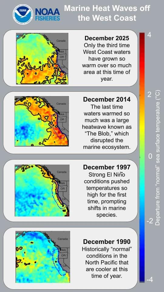
Marine heat waves off the West coast, showing departure from normal sea surface temperatures, 1990-2025. Credit: NOAA Fisheries/Southwest Fisheries Science Center
What made NEP25A so consequential was its refusal to dissipate. CNN described it as spanning 5,000 miles from Japan to California. AccuWeather noted it was larger in geographic scope than the original 2013-2015 Blob. NOAA's Andrew Leising noted it was 'not a situation that we have seen before.'
A new study published in npj Climate and Atmospheric Science identified Arctic warming as a potential trigger for warm blobs in the northeast Pacific. Research in Nature Communications documented how extratropical atmospheric teleconnections sustain these anomalies. OPB reported the marine heat wave's return in October 2025, while Jefferson Public Radio noted it had initially 'spared' Oregon and Washington — a reprieve that didn't last.
The mechanism linking warm North Pacific SSTs to snow drought is well-documented: anomalously warm ocean surfaces build geopotential heights and induce a persistent high-pressure ridge — the Pacific-North American teleconnection pattern — that deflects the polar jet stream northward, sending Pacific storms into Alaska rather than the western U.S. A 2024 PNAS study identified a wind-evaporation-SST feedback loop that intensifies these events, partly driven by abatement of Chinese aerosol emissions over the past decade.
2. The Ridiculously Resilient Ridge Returns
The atmospheric pattern dominating winter 2025-26 was a textbook North American Winter Dipole: a persistent high-pressure ridge anchored off the Pacific coast, paired with a deep trough over eastern North America. The original 'Ridiculously Resilient Ridge' (RRR) — named by UCLA's Daniel Swain in December 2013 — had returned in an even more damaging configuration.
Unlike the 2013-15 version, which sat in the Gulf of Alaska, the 2025-26 ridge was positioned further south, directly off the California coast. This placement was devastating — it blocked undercutting storms entirely. By March 2026, California Water Research described it as 'the strongest cool-season ridge ever observed in the southwestern United States.'
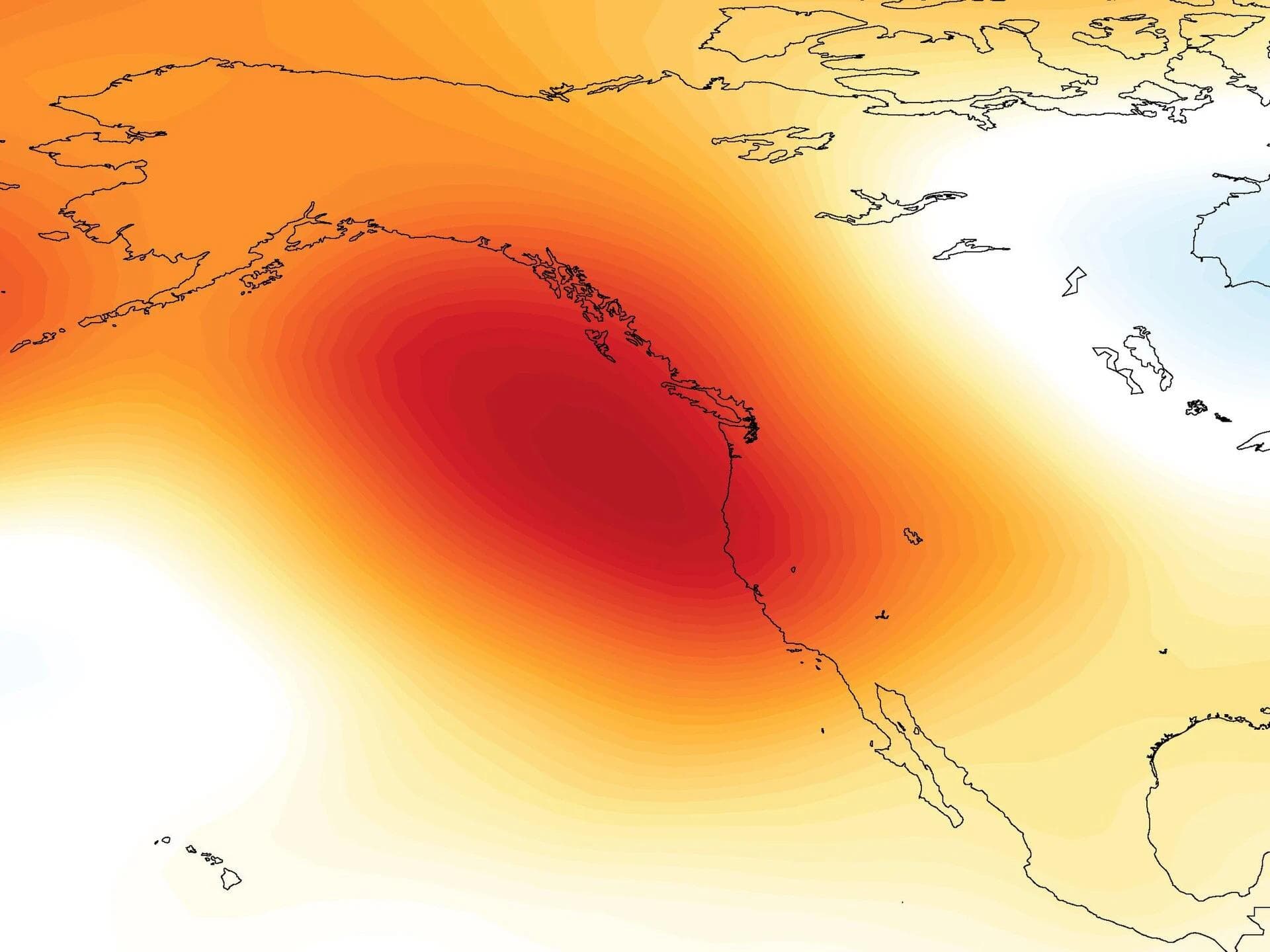
The Ridiculously Resilient Ridge, here depicted by cool-season seasonal geopotential height anomalies (November–March) during 2012–2015.
The 'tale of two winters' was stark: while the West baked, Cowboy State Daily documented that 'almost no snow fell for Wyoming, while the east got hammered.' Providence and Islip, NY recorded their snowiest winters on record; Toronto saw its largest single-day snowfall since 1937.
Emerging research suggests this dipole pattern reflects a structural shift in North American winter circulation. Yale Climate Connections describes 'a growing body of research suggesting the winter atmospheric circulation over North America appears to have shifted... the atmosphere has been restructured in a way that favors extreme ridges over the West.' The Water Education Foundation has documented the RRR's connection to California water planning.
3. La Niña and the QBO
The ENSO state during winter 2025-26 was a weak La Niña, with Niño-3.4 ONI values hovering between -0.5°C and -0.7°C. NOAA's Climate Prediction Center issued its La Niña advisory on October 9, 2025. By April 2026, conditions had returned to ENSO-neutral with an El Niño Watch issued. Australia's Bureau of Meteorology confirmed the transition in late March.
La Niña alone did not explain the severity. Even the Pacific Northwest — La Niña's usual beneficiary — saw its snowpack destroyed. The marine heat wave and background warming overwhelmed La Niña's modest signal. OpenSnow's mid-winter update confirmed: 'a weak La Niña combined with an easterly QBO tends to favor high-pressure ridges in the Western US and troughs in the East, and that has been the case so far this season.'
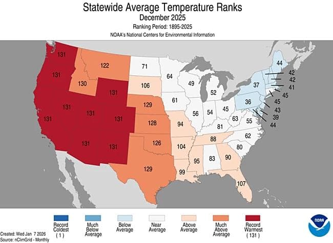
9 out of 11 states in the Western U.S. just experienced their warmest December on record out of 131 years of data, per NOAA's monthly climate report.
The Quasi-Biennial Oscillation (QBO) was in a strongly easterly (negative) phase, with the September 2025 index at 50mb reaching -24.26 — one of the strongest easterly episodes in recent decades. Netweather's winter preview highlighted how this 'increased the risk of Stratospheric warming' and favored blocking patterns over the West. Easterly QBO winters favor high-pressure ridging near the West Coast and troughing over the Northeast — precisely the pattern that dominated.
OpenSnow's fall 2025 update, 'Checking In on La Niña and the Pacific Blob', warned that 'in past years, the combination of cold water south of Greenland and these QBO winds in an easterly phase have overcome a weak ENSO signal, or La Niña, and increased the likelihood of a high-pressure ridge in the western US.'
4. Record Warmth: A Season of Broken Thermometers
Winter 2025-26 (December–February) was the second-warmest in the 131-year U.S. record, with a contiguous-state average of 37.1°F — 4.9°F above the 20th-century average. AccuWeather reported that nine states set all-time warmest winter records: Arizona, Colorado, Nevada, New Mexico, Oregon, Utah, Wyoming, Texas, and Oklahoma. Arizona and New Mexico broke their previous records by more than 2°F.
The mountain West bore the brunt. Yale Climate Connections reported it was 'the second-warmest winter in U.S. history.' Riverton, Wyoming ran 13.5°F above normal; Grand Junction, Colorado 10.1°F above; Denver 9.3°F above. Colorado Public Radio documented record December heat in Denver and Boulder County. Aspen Times confirmed Colorado's December broke records at mountain towns, with Steamboat Springs recording its hottest December since 1893.
The critical metric was the rain-snow line. In November storms over California, the rain-snow line sat at approximately 9,000 feet, meaning only the highest summit areas received snow. During the second week of January, rain fell to 7,000 feet in Washington and coastal BC. The University of Denver paleoclimatologist commentary described it as 'record warmth, little snowfall.'
The March 2026 heat wave was the coup de grâce. Weather West's Daniel Swain called it 'extraordinary and prolonged' and warned it would 'decimate mountain snowpack.' The US all-time March temperature record was broken on three consecutive days, peaking at 112°F at Fort Yuma, Arizona on March 20. Yale Climate Connections described 'mind-blowing records melting from Arizona to Minnesota.'
The World Weather Attribution group published a rapid attribution study on March 20, 2026 — during the heat wave itself. Their central finding: the event was 'virtually impossible without human-induced climate change.' Climate change added an estimated 2.6–4°C (4.7–7.2°F) to temperatures. In today's 1.3°C-warmer world, such events have a return period of roughly 500 years, but have become approximately four times more likely in just the past decade. Yale Climate Connections and Inside Climate News both confirmed the attribution findings.
5. Snowpack Records Shattered Across Eight States
By April 1, DROUGHT.GOV reported that 64% of all SNOTEL and snow course stations (1,012 of 1,570) across the West tied or set new record-low SWE values. Key state snapshots:
Colorado: Statewide snowpack on April 1 measured just 22% of the 30-year median — the worst on record. Sixty of 64 manual snow course sites set new lows. Summit Daily and Aspen Times confirmed it was 'officially Colorado's worst snowpack year on record.' USDA NRCS noted 18 sites had zero snow — unprecedented for April 1.
Utah: The Park Record reported 2026 snowpack was 'the lowest ever recorded since measurements began in 1930.' The next-lowest year (2015) was roughly five times higher. Western Water documented the state-level record.
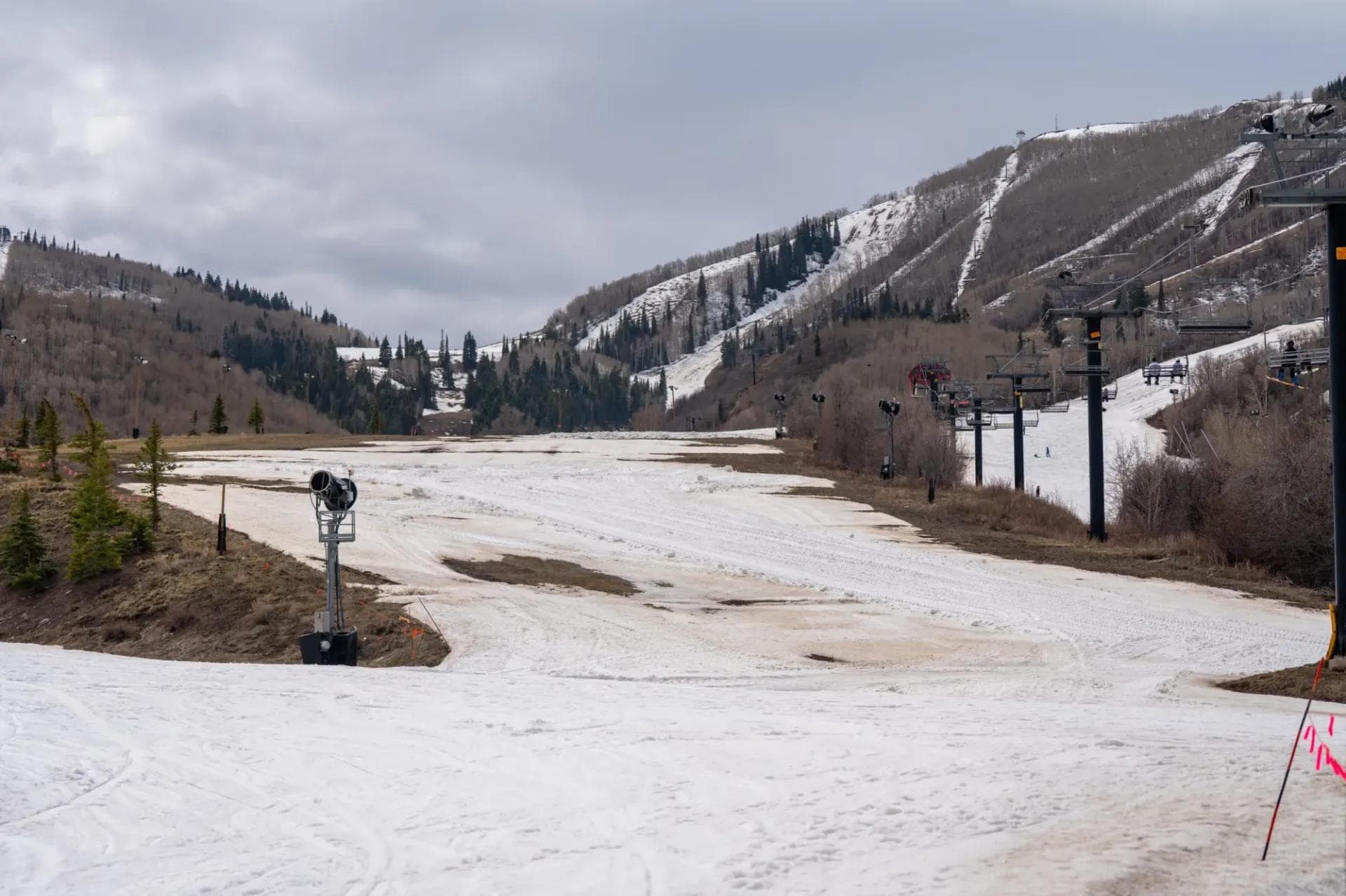
Snow conditions were poor at Park City Mountain on March 23, 2026. Credit: Jonathan Herrera/Park Record
California: The state's Department of Water Resources reported 'record hot, dry March wipes out California snowpack, leaving no measurable snow for April survey.' SnowBrains noted April 2026 snowpack at 18% of average after record heat.
Oregon: The state's worst season on record. KTVZ documented the 'March meltdown: historic low snowpack hits Central Oregon.' SKI Area Management reported indefinite closures across Oregon ski areas.
Across the West, NASA Science documented the snow drought in satellite imagery. NBC News summarized 'western states face snow drought as snowpack hits record lows.' Scientific American called the April 1 snowpack picture 'utterly dismal.'

January 15, 2026 Snowpack as shown by NASA Science satellite imagery
6. Season Timeline: How It Unraveled
The disaster didn't arrive all at once. BestSnow's 2025-26 Season Progress Report tracks the full arc. Early October brought optimism — Keystone and A-Basin opened October 26-27. But November was nearly snowless south of Oregon and Wyoming, with high rain-snow lines on every storm.
December was catastrophic. Drought.gov's December 11 update flagged severe early-season snow drought. After a brief first-week storm, a two-week dry spell doomed Christmas skiing. Powderchasers documented the deteriorating January outlook. By January 8, Drought.gov confirmed the catastrophic start. By February 5 the blocking pattern was fully entrenched. March 12 showed the heat wave beginning its damage. April 9 captured the historic final reckoning.
Colorado's snowpack peaked on March 9 at just 51% of median — the lowest peak ever recorded — nearly a month before the average peak date. Colorado's Dust-on-Snow Program described the April 1 situation as 'Peak SWE, or Snow-All-Gone?' — a painfully apt question. SnowBrains' April 2026 state-of-snowpack update asked: 'Worst Snow Year Ever?' The answer was yes.
The Park Record's January expert roundup warned that 'western snowpack crisis signals a new climate reality for mountain towns.' Utah's University of Utah scientist Kevin Perry stated in early February: 'We're in uncharted territory right now.' Colorado Sun described Colorado resorts 'limping toward closing during record heat.'
7. Precipitation: Rain Not Snow
A critical nuance: total precipitation was near or above normal across much of the West in the first half of the season — this was fundamentally a temperature problem, not a moisture deficit. The Conversation / Maven's Notebook explains 'winter's alarmingly low snowpack offers a glimpse of the changing rhythm of water in the western US.'
Oregon's Hood/Sandy/Lower Deschutes basin received 120% of median precipitation but accumulated only 29% of median SWE — a stark illustration. Stocktonia and Times of San Diego both covered the 'changing rhythm of water in the western US.'
The season unfolded in two phases: first a 'wet snow drought' (Nov-Dec) where moisture arrived as rain, then a 'dry snow drought' (Jan-March) where the blocking ridge cut off precipitation entirely. Weather West documented the 'whiplash transition from record warmth to heavy snowfall' during the brief February respite. The University of New Mexico explained the 'unusually warm, dry Southwest winter.'
8. Ski Industry: Economic Carnage
The financial toll was severe across the industry. Vail Resorts' Q2 FY2026 earnings release told the story in numbers: skier visits through January 4 were down 20.0% year-over-year, ski school revenue fell 14.9%, dining fell 15.9%. CEO Rob Katz called it 'the most challenging winter across the Rockies that we have ever experienced.' PR Newswire detailed the ~$97-123M guidance cut. Colorado Public Radio summarized 'Vail's earnings are going downhill.'
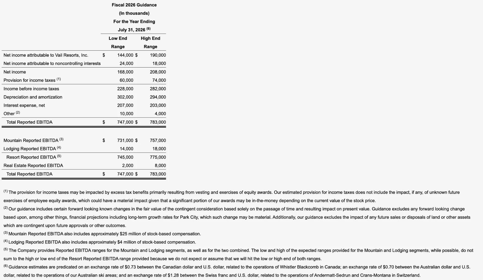
The following table reflects the forecasted guidance range for the Company's fiscal year ending July 31, 2026 for Total Reported EBITDA (after stock-based compensation expense) and reconciles net income attributable to Vail Resorts, Inc. guidance to such Total Reported EBITDA guidance.
Across the West, SnowBrains tracked 69+ early closures, while Unofficial Networks documented 'a list of all western U.S. ski resorts closing earlier than expected.' The Inertia reported 'California's Largest Ski Resort Will Close a Full Month Early.' Vail Mountain itself announced an early closing date.
Oregon's ski industry was decimated. OPB reported 'As the West faces an unprecedented snow drought, ski resorts are left scrambling.' Mt. Ashland operated just 17 days all season.
Mountain town workers suffered cascading effects. 5280 Magazine documented ski-town workers 'stuck in a tailspin.' KUNC reported that 'some Colorado ski resorts are reducing employee hours.' SnowBrains surveyed western skiers and found that 70% still wouldn't fly east to ski despite the disaster at home.
Colorado's ski industry normally generates $4.8 billion in annual economic output and supports 46,000 year-round equivalent jobs — per RRC Associates. MMCG's financial analysis of Vail Resorts described 'an epic downturn.'
9. Beyond Skiing: Water, Wildfire, and Drought
The snowpack collapse had immediate consequences for water supply. Denver Water declared Stage 1 drought on March 25, its first since 2013, seeking a 20% reduction in use. Colorado Sun reported 'Denver issues water restrictions for unprecedented drought.' FOX31 Denver confirmed mandatory watering restrictions.
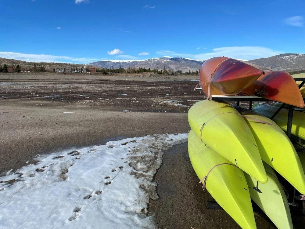
Summer recreation at Dillon Reservoir will be hampered by this winter's historically low snowpack. Photo credit: Denver Water.
Wildfire risk soared. NPR reported 'light snowpack is setting up conditions for drought and fires in the U.S. West.' This Is Reno documented '2026's historic snow drought brings worries about water, wildfires and the future in the West.' E&E News reported that 'heat, drought and wildfire shatter records in the West.'
The Sierra Club framed the crisis: 'Western snow drought threatens ski season and much more.' CNN published before-and-after satellite images showing 'how little snow is left in the western US.' CalMatters documented 'record heat melts California's snowpack early.'
10. Climate Change Context: Acceleration Ahead of Schedule
The 2025-26 season sits atop a well-documented long-term decline. The Washington State Climate Office's March 2026 snowpack summary provided state-level context. Climate Central calculated that water stored in the western snowpack on April 1 was 65% below the 1991-2020 average — the lowest on record by a wide margin.
The long-term science is unambiguous. Mote et al. (2018) in npj Climate and Atmospheric Science found over 90% of monitoring sites show declining trends, with total snowpack down 15-30% since 1915. A landmark 2024 study in Nature found 'evidence of human influence on Northern Hemisphere snow loss.' Oregon Capital Chronicle and Washington State Standard both covered the findings.
The Drought.gov background piece on climate change and snowpack confirms 'climate change behind sharp drop in snowpack since 1980s.' The Revelator asked 'A Future With Little to No Snow? What That Means for the West.'
What alarmed scientists most was the timing. Siirila-Woodburn and Rhoades (2021) projected SWE declines of 25% by 2050 and 50% by 2100 under high emissions, with 'low-to-no-snow winters' becoming regular in 35–60 years. The 2025-26 season, at 65% below the 1991–2020 average, exceeded the 2050 projections in severity. Cornell's Flavio Lehner stated on April 1: 'Our research suggests these kinds of conditions will become common after 2050 — one in every five years might be like this, so this year is a glimpse into the future.'
Boise State's Alejandro Flores called the season a 'high-stakes stress test' with 'few historical analogs.' Montana Public Radio reported 'lower MT snowpack may be glimpse of future.' Insight News and Bozeman Daily Chronicle both carried 'worries about water, wildfires and the future in the West.'
For the ski industry specifically, Deseret News previously asked 'What will the ski industry look like in 50 years?' A ScienceDirect study projected winter recreation season lengths exceeding 50% reductions at some locations by 2050. Eos examined how 'the ski industry stopped worrying and learned to love climate activism.' Colorado Politics summarized: 'Colorado's low snowpack hurts ski industry, may mean drought.'
Conclusion
The 2025-26 western snow drought required the simultaneous alignment of a record-breaking marine heat wave (NEP25A), a strongly easterly QBO that favored western ridging, a weak La Niña that failed to break it, and a background climate now nearly 1.3°C warmer than preindustrial levels. The marine heat wave built the ridge. The QBO reinforced it. La Niña was too weak to break it. And climate change loaded the dice for warmth at every stage — elevating rain-snow lines, accelerating melt, and producing a March heat wave deemed 'virtually impossible' without human influence.
Three insights stand out. First, the distinction between 'wet' and 'dry' snow droughts is crucial: the early-season problem wasn't missing precipitation but precipitation arriving as rain at 9,000 feet. Second, the North American Winter Dipole appears to be strengthening as a structural feature of the climate system, not merely natural variability. Third, the season exceeded mid-century projections in severity.
The western snowpack — long treated as a free, self-replenishing reservoir — is losing its reliability in real time. As The Conversation's overview put it: 'Winter's alarmingly low snowpack offers a glimpse of the changing rhythm of water in the western US.' The 2025-26 season made that loss impossible to ignore.
Research compiled from NOAA, NASA, World Weather Attribution, Drought.gov, Yale Climate Connections, SnowBrains, OpenSnow, Powderchasers, Colorado Public Radio, Denver Water, and multiple peer-reviewed sources. All citations are hyperlinked throughout the document.