
South America's First Major Storm of 2026: Early-Season Andes Totals
Published Date:

Melbourne-based skier and snowboarder with 50+ resorts across 5 continents. Specialises in Australian resorts and international resort comparisons.

South America's 2026 ski season hasn't opened yet, but the Andes are already making a statement
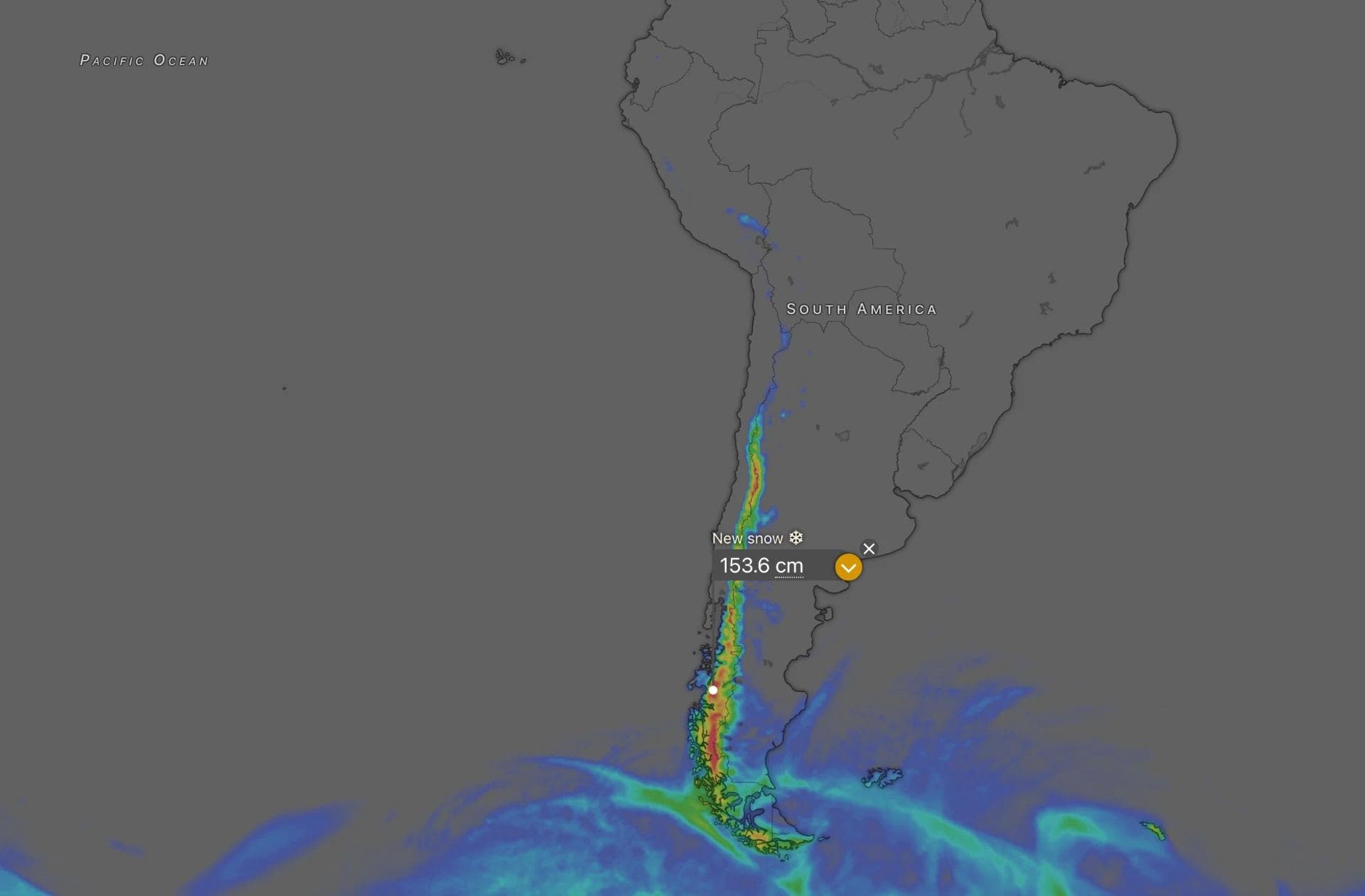
The lifts are still down across Chile and Argentina, but the mountains aren't waiting for opening weekend to get started. A significant early-season storm is currently moving through the Andes, with the main snow window running through Friday, June 12. OpenSnow's Powder Finder is tracking the event across the full length of the range, and the central Andes are shaping up as the standout zone.
None of this snow is rideable yet - lift-served skiing remains closed across the region - but a storm of this size this early does meaningful work on the snowpack. Valle Nevado is showing an opening date of June 19 on OpenSnow, which would put it among the first doors open in the region if the base keeps building.
Central Andes leading the way
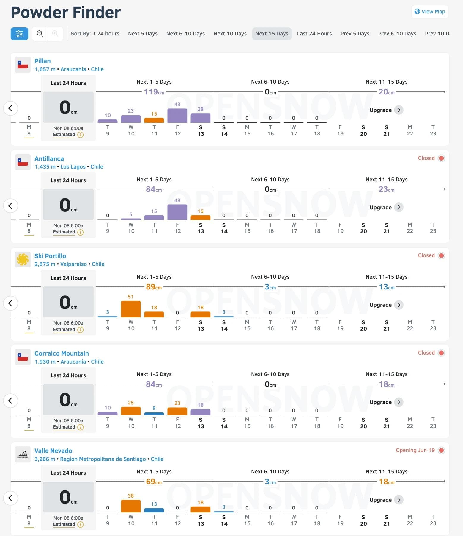
The strongest numbers are sitting across the high central Andes. Portillo tops the OpenSnow Powder Finder at 89 cm for the next five days, with Valle Nevado at 69 cm, La Parva at 64 cm and El Colorado at 56 cm. These are the resorts clustered around and above Santiago, sitting between roughly 2,400 and 3,300 metres, and the storm is targeting exactly the elevations where snow quality tends to be at its best - snow levels during the main push are running low enough for light to moderate snow across the higher terrain.
Los Puquios, a lesser-known resort in Mendoza province on the Argentine side, is showing 66 cm - a number that will raise eyebrows for anyone familiar with the region's more under-the-radar options.
Strong totals further south too
Further south, the numbers are also worth watching. Antillanca and Corralco - both sitting in Chile's Araucanía region - are each showing 84 cm on OpenSnow, which puts them right alongside the central Andes leaders in raw total terms. Nevados de Chillán is at 61 cm, and Chapa Verde at 51 cm. Snow character in these zones tends to run denser and wetter than the high central Andes, which makes them better suited to base-building than powder days - but at these totals, the snowpack will be significantly better off by the weekend.
Into Argentine Patagonia, the totals step down but remain meaningful for early June. Chapelco is at 46 cm, Cerro Bayo at 46 cm, Cerro Catedral Alta Patagonia at 36 cm, and Las Leñas - despite its elevation and latitude in Mendoza province - at 38 cm. At the far southern end, Cerro Castor in Tierra del Fuego is tracking 18 cm over the same period, with an additional 18 cm in the six to ten day window beyond that.

OpenSnow 5-day forecast totals (June 9-13)
- Portillo - 89 cm
- Antillanca - 84 cm
- Corralco - 84 cm
- Valle Nevado - 69 cm
- La Parva - 64 cm
- Nevados de Chillán - 61 cm
- Los Puquios - 66 cm
- El Colorado - 56 cm
- Chapa Verde - 51 cm
- Chapelco - 46 cm
- Cerro Bayo - 46 cm
- Las Leñas - 38 cm
- Cerro Catedral Alta Patagonia - 36 cm
- Antuco - 36 cm Perito Moreno - 38 cm
- Farellones - 30 cm
- Caviahue - 28 cm
- Cerro Castor - 18 cm
Forecast data: OpenSnow Powder Finder, June 9 2026.
A weekend reload is possible
Beyond Friday, model confidence drops off. A second pulse targeting the central Andes looks plausible through the weekend, but timing and intensity remain uncertain - drier solutions are still on the table. Southern areas look more intermittent. For now, the first wave is the one to watch, and it's shaping up as a strong opening act for the 2026 season.