
Tuckerman Ravine Avalanche Danger Reaches Considerable Level
Published Date:

Melbourne-based skier and snowboarder with 50+ resorts across 5 continents. Specialises in Australian resorts and international resort comparisons.

Considerable avalanche risk at Tuckerman Ravine following skier-triggered slide
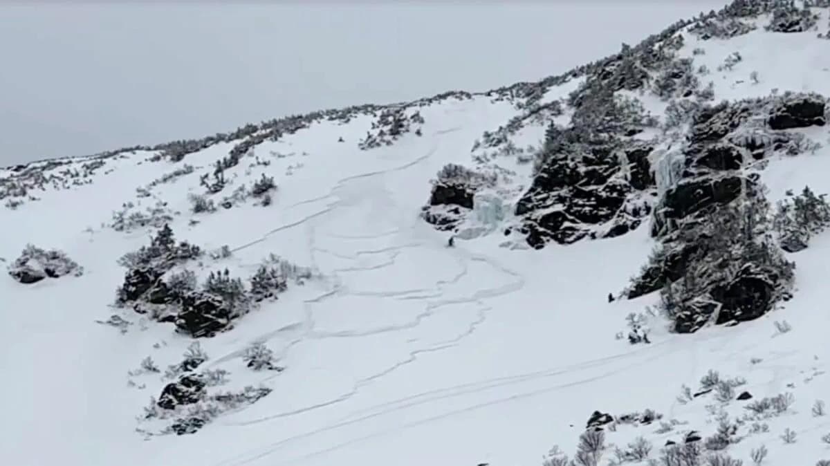
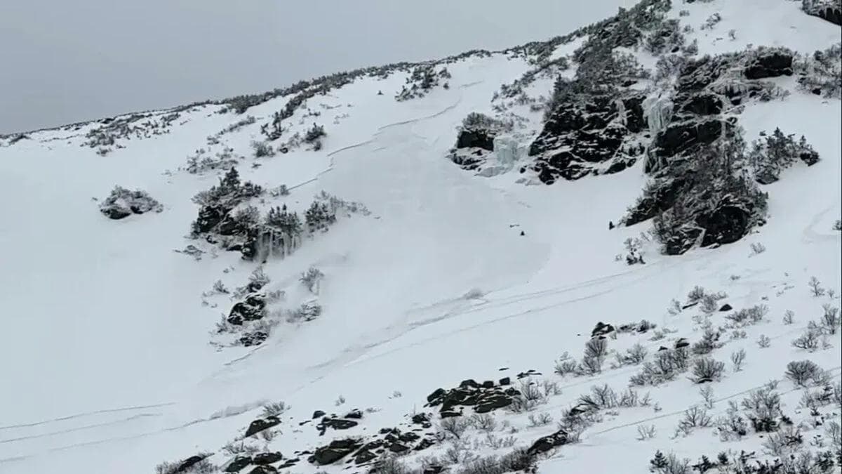
The Mount Washington Avalanche Center has escalated avalanche danger ratings to 'considerable' for terrain above 3,000 feet at Tuckerman Ravine and surrounding areas, with the warning in effect through at least Wednesday. The elevated rating comes after a skier triggered an avalanche while descending the Sluice last week, highlighting deteriorating snowpack stability across north, east and south-facing slopes.
The Centre is warning that both human-triggered and natural avalanches are possible under current conditions. For Australians familiar with backcountry terrain, 'considerable' sits at level three on the five-point North American avalanche danger scale - the point where experienced backcountry users start seriously reconsidering their plans.
Wind loading creating dangerous slab conditions
The primary concern centres on wind-transported snow creating deep drifts on top of an already compromised snowpack. Forecast winds of 50-70 mph early in the day are expected to build wind slabs over poor structural layers deeper in the snowpack. The Centre specifically advises watching for smooth, pillowy drifts - visual indicators of potentially unstable wind-loaded snow.
According to recent forecaster observations, the core problem is poor snowpack structure within new snow sitting on top of a firm melt-freeze crust. The size of potential avalanches depends on whether slabs release only on a thin rimed surface crust (producing smaller slides) or involve all snow down to the melt-freeze layer (producing large avalanches).
Snowpack structure adds uncertainty
Interestingly, the Mount Washington Observatory recorded snowpack height decreasing from 8 inches to 5 inches over a six-hour period overnight, suggesting settlement or wind transport is already occurring. Solar gain and surface riming may actually limit some snow redistribution, though this provides cold comfort when winds are forecast to hit 70 mph.
The alpine snowpack remains patchy and disconnected in many areas after significant earlier losses, which may somewhat limit loading potential as new snow falls directly onto rock rather than smooth snow surfaces. However, this also means whatever slabs do form will be sitting on particularly variable terrain.
Recent avalanche activity
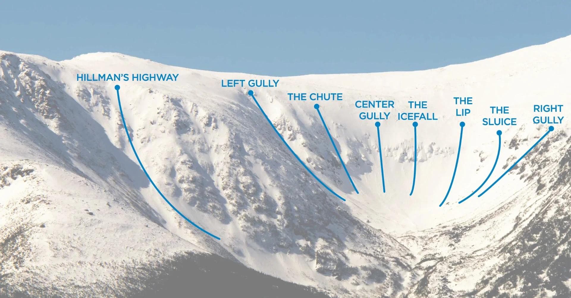
Last week's incident in the Sluice - one of Tuckerman Ravine's more technical descents - demonstrates current instabilities aren't theoretical. Video documentation of the slide shows exactly the kind of scenario backcountry users need to avoid: a skier-triggered release on steep, loaded terrain with poor snowpack structure beneath.
The Mount Washington Avalanche Center's guidance is straightforward enough - travel on firm surfaces, avoid smooth pillow drifts, and make conservative route choices, particularly on steep east-facing slopes. They're also requesting backcountry users submit observations through their website or the Avy phone app, which seems reasonable given how variable conditions are proving.
For context, Tuckerman Ravine attracts significant attention in the North American backcountry skiing community - it's accessible, challenging, and operates without lift infrastructure or ski patrol mitigation. That means personal avalanche assessment skills aren't optional; they're the only safety system in place.
The current situation highlights a common avalanche cycle pattern: new snow, wind transport, and weak layers create a temporarily dangerous period that requires either staying out of avalanche terrain entirely or having the skills and equipment to make informed decisions in the field. The Centre's forecast suggests conditions may improve as winds decrease through the afternoon, but anyone heading into this terrain should be monitoring real-time observations and prepared to adjust plans accordingly.
Whether these conditions persist beyond Wednesday depends largely on wind speeds and any additional precipitation. The forecast discussion indicates considerable uncertainty around how much transportable snow remains available and exactly how aggressive the wind loading will become.