
Axamer Lizum
780m vertical, 40km of runs, 9 lifts. Two-time Olympic venue (1964 & 1976). Free ski bus from Innsbruck city centre. Stubai Alps, Austria.
Season 2026 - 2027
Opens
28 Nov 2026
Closes
11 Apr 2027
Days open
134
Annual snow
3m
The Overview
Michael Fulton
Melbourne-based skier and snowboarder with 50+ resorts across 5 continents. Specialises in Australian resorts and international resort comparisons.
Axamer Lizum operates between 1,560 and 2,340 metres, delivering 40 kilometres of marked piste across a vertical drop of 780 metres — the largest ski area in the immediate Innsbruck region. Five ski routes add a further 10,000 metres of vertical across 300 hectares of designated freeride terrain in the high cirque beneath the Kalkkögel. The resort hosted alpine skiing at both the 1964 and 1976 Innsbruck Winter Olympics, with the Olympiabahn funicular built for the 1976 Games still carrying skiers to the summit daily. Known as the White Roof of the Innsbruck Olympic Region, Axamer Lizum maintains one of the most reliable snow records of any non-glacier resort in the northern Alps.
The ski area divides terrain into 18% beginner, 39% intermediate, 30% advanced and 13% expert across 24 marked runs. The Olympia Damenabfahrt (women's Olympic downhill course) descends 3.2 kilometres from the Hoadl summit and serves as an accessible red-graded run — ideal for ambitious intermediates following in the tracks of Olympic champions. The Birgitzköpfl sector at 2,035 metres houses the resort's steepest terrain: a renowned mogul slope that drops 475 vertical metres and several ski routes into the Götzner Grube bowl. The Golden Roofpark — named after Innsbruck's famous medieval landmark — sits at 2,110 metres and features jumps, rails and kickers shaped for all freestyle ability levels.
The Hoadl-Haus panorama restaurant at 2,340 metres boasts the largest covered sun terrace in Austria, with unobstructed views across Innsbruck, the Inn Valley and the Nordkette range — and its elevated position means the terrace catches sun from mid-morning through late afternoon. The Birgitzköpflhaus on the opposite side of the ski area reopened for 2025-26 after renovation, providing a traditional Tyrolean mountain hut experience at 2,035 metres. Beginner areas at Kaserwald and Talboden at the valley floor allow first-timers to build confidence independently from the main gondola. A free ski bus connects Innsbruck city centre to the resort throughout the season, making car-free access straightforward from one of Europe's most liveable Alpine cities.
Adult day passes start from €56.50 to €63 depending on the period, with children (6-15) paying €34 to €38 and seniors €51 to €56.50. Season passes run from €645 for adults, €580 for seniors and €387 for children. Prices shown are based on the most recently published 2025-26 rates; 2026-27 pricing will be confirmed by the resort ahead of the season opening. Flexible afternoon and two-hour passes make the resort practical as an after-work or half-day destination from Innsbruck. The resort suits confident intermediates and advanced skiers after genuine challenge — the Olympic ski routes demand respect — whilst the wide piste network and consistent grooming make it equally rewarding for families seeking a reliable day on the mountain.
780m
Vertical
24
Runs
40 km
Piste
3m
Annual snow
Tyrol Pass
Pass
The Terrain
24 runs across 40 km of piste
Axamer Lizum fits 24 marked runs and 40 kilometres of piste into the high cirque above Axams, with every descent falling from the Hoadl summit at 2,340 metres towards a base at 1,560 metres. That 780-metre vertical is modest, but the difficulty split is unusually steep for a ski area this close to Innsbruck: 30% of the terrain is graded advanced and 13% expert, against 39% intermediate and only 18% beginner. Gentle cruising is limited here, while strong skiers get a day of sustained red and black pistes that the run count alone does not suggest.
The Olympia Damenabfahrt is the run most visitors head for, a 3.2-kilometre red descent from the Hoadl summit that follows an Olympic downhill course. Beyond the groomed network, around 300 hectares of open terrain and numerous north-facing slopes hold powder well after a storm, which makes Axamer Lizum a serious freeride option for skiers staying in Innsbruck. Those bowls sit beneath the Kalkkögel limestone peaks and above the treeline, so avalanche gear, a guide or local knowledge is the sensible way to explore them.
Terrain split
24
runs
24 runs across 4 grades
Beginner4 runs · 18%
Intermediate9 runs · 39%
Advanced7 runs · 30%
Expert3 runs · 13%
Time it right
When to visit Axamer Lizum
The 2026-27 season is projected to run from 28 November 2026 to 11 April 2027, with operating hours from 08:30 to 16:00 daily. The resort typically opens in late November with Athletes Ski Test Days — a tradition inviting skiers to demo equipment from top winter sports brands at the valley station. High season pricing historically applies from late December through late March, with shoulder-season rates before and after. The peak winter period is one of the longest for any ski area of this size in the Innsbruck region, reflecting Axamer Lizum's altitude and north-facing aspects that retain snow well into spring.
Annual snowfall averages 188 centimetres at resort level, with the high-altitude terrain above 2,000 metres receiving substantially more across its north-facing slopes. The resort's position against the main Alpine watershed captures moisture-laden Atlantic systems before they dissipate into the Inn Valley, delivering reliable accumulation from December through March. A total of 136 snow cannons cover approximately 85% of the piste network — among the most comprehensive snowmaking installations in the Innsbruck ski region — ensuring groomed conditions throughout the season even during natural snow gaps. Natural snow depth at 2,000 metres typically exceeds 100 centimetres by February.
December and early January offer the longest ski days and the best off-peak value with shoulder-season pricing and manageable crowds. January and February deliver the coldest temperatures and most consistent powder across the Kalkkögel freeride zones, with the ski routes above 2,000 metres often holding dry snow longer than lower resorts after a dump. March is considered the sweet spot by regulars: long sunny days, firm morning snow on the wide Olympic pistes and soft afternoon corn on south aspects, combined with the full 40-kilometre piste network in operation. April skiing remains possible on the upper Hoadl terrain through to the projected 11 April closing date.
The season traditionally opens with Athletes Ski Test Days in late November, with winter sports brands offering equipment testing at the base. The Mammut Safety Roadshow in January delivers free avalanche safety training and equipment demonstrations — highly relevant given the extensive freeride terrain available at the resort. The Hoadl Rave electronic music event brings après-ski entertainment to the mountain in mid-January. A Valentines Day and Singles Day event runs in February, and the season closes with Ugly Skiing Day — a longstanding tradition inviting skiers to wear outrageous outfits for the final weekend. Specific 2026-27 event dates will be confirmed by the resort ahead of the season.
Season 2026 - 2027
28 Nov 2026
Opens
11 Apr 2027
Closes
134
Days open
3 m
Annual snow
Getting there
Getting to Axamer Lizum, and where to stay
Axamer Lizum occupies a high alpine cirque in the Stubai Alps of the Innsbruck-Land district in Tyrol, Austria, sitting 19 kilometres southwest of Innsbruck city centre at the head of the Axams valley. The ski area lies at the foot of the Kalkkögel massif — known as the Dolomites of North Tyrol for their dramatic limestone spires — with the Hoadl peak at 2,340 metres forming the highest accessible point. The name Lizum derives from the Tyrolean dialect word for a muddy mountain pasture, though in winter the terrain transforms into the most reliably snow-covered non-glacier ski area in the Innsbruck region. The surrounding landscape falls within the Kalkkögel Nature Reserve, protecting the high-altitude terrain from further development.
Innsbruck city centre lies 19 kilometres northeast and approximately 30 minutes by car or free ski bus — making Axamer Lizum one of the most accessible major ski areas from any European city. The village of Axams sits 8 kilometres below the resort at 870 metres, offering traditional Tyrolean accommodation and a short bus connection. Götzens lies 11 kilometres away and also connects via ski bus. The broader Innsbruck ski region encompasses multiple separate ski areas: Patscherkofel to the east hosted the men's downhill at both the 1964 and 1976 Olympics, and Stubaital's Schlick 2000 is 20 kilometres further southwest.
Innsbruck Airport (INN) sits just 22 kilometres from the resort and approximately 30 minutes by road — one of the shortest airport-to-slope transfers of any major Austrian ski resort. Innsbruck Airport handles direct flights from London Heathrow, Amsterdam, Frankfurt, Rome, Dublin and seasonal ski charter services. Munich Airport lies 175 kilometres north via the A12 and A93 autobahns, approximately 1 hour 45 minutes in normal conditions, and serves as the primary hub for transatlantic connections. Salzburg Airport is 185 kilometres northeast and around 2 hours via the A8.
Innsbruck Hauptbahnhof receives direct rail services from Vienna (3.5 hours), Munich (1.75 hours), Zürich (3.5 hours), Milan (4 hours) and Verona (2.5 hours), making it one of the most rail-connected ski resort access points in the Alps. Free ski buses operate directly from Innsbruck city centre to the Axamer Lizum valley station throughout the winter season, with buses also stopping in Axams and Götzens along the route. The full journey from Innsbruck train station to the ski area car park takes approximately 35 minutes. Additional bus services from the ÖBB Postbus network link surrounding villages to the resort on a regular timetable.
Where to stay
Search all stays →Hotels and lodges near Axamer Lizum, powered by Stay22.
Latest News
From the SnowStash desk

Europe Ski Resorts Open Now: What Is Skiable in Mid-October 2026
Europe’s ski season is open, technically. After a record-warm summer, glaciers in Austria, Switzerland and Italy are running a few pistes apiece, Sölden, Stubai and Kitzsteinhorn started late, Titlis has pushed back to 24 October, and Zermatt reopens a few lifts on 14 October after more than two months shut. Finland’s Levi and Ruka are skiing on stored snow. Here is what is open, and what you actually get at each.
14 Oct 2026

Zermatt Plans World Cup Downhill Return on the Gornergrat for 2028
Zermatt is having another crack at a World Cup downhill, and this time nobody has to cross a border. Around 13 million Swiss francs is going into rebuilding the Gornergrat piste, including a jump fed by a roughly 300-metre in-run across the roof of the Gornergrat Railway gallery, with the Matterhorn lined up behind it for the TV cameras. First men’s race is pencilled in for March 2028, pending FIS homologation.
14 Oct 2026

Mt. Rose Begins Snowmaking for the 2026-27 Season at Lake Tahoe
Lake Tahoe’s highest base elevation is paying off early: Mt. Rose has started making snow for 2026-27 after the first flurries and a cold snap. The Nevada resort is backing it with nearly US$2 million in upgrades, including a replacement snowmaking main line, a new PistenBully groomer and restraint bars on every lift. Opening day is yet to be confirmed, though Heavenly and Northstar are already eyeing 20 November.
13 Oct 2026

Utah Ski Resorts 2026-27: What’s New at Alta, Deer Valley, Powder Mountain and More
Utah is still building flat out. For 2026-27, Powder Mountain opens a steep new Skytrac chair into more than 1,000 acres of advanced terrain, Deer Valley adds 200 acres on Hail Peak, Sundance gets a new quad and Park City adds a gondola from its new parking structure. Snowmaking is expanding almost everywhere, Eagle Point stays closed after the Cottonwood Fire, and the 2034 Games are setting the pace. Here’s what’s new, resort by resort.
13 Oct 2026

Mt Hutt Invests NZ$12 Million in Base Area, Tripling Its Sun Deck
Mt Hutt is getting busier, and its base lodge is about to catch up. NZ$12 million goes into a heated sun deck roughly three times the current size (430 m² to 1,300 m²), plus a new toilet block, heated steps down to snow level, extra storage and a new food and beverage outlet. Building starts after the 2026 season, with everything due for winter 2027.
11 Oct 2026

Vermont Ski Resort Opening Dates 2026-27: Few Dates Set, Killington Waits on the Cold
Vermont's season is slow to take shape. Stratton is tentatively targeting 18 November and Sugarbush 21 November, while Pico has Friday 11 December on the calendar. Killington never sets a date and opens when the snowmaking allows, and Vail Resorts has yet to name days for Stowe, Okemo and Mount Snow. The forecasts disagree about snow, and the main El Niño worry for the Green Mountains is warmth.
9 Oct 2026
Crans-Montana 2027 World Championships President Resigns Ahead of Fraud Hearing
Less than four months out from the Crans-Montana 2027 World Championships, the man running the organising committee has stepped down. Claude-Alain Schmidhalter resigned as Swiss-Ski vice president and OC president after being indicted over a business dispute unrelated to skiing. He denies the allegations and faces court on October 27. Interim leaders are in place for the February 1-14 event.
9 Oct 2026
Kelly Canyon, Idaho, Adds Snowmaking, a Bigger Terrain Park and More Parking for 2026-27
Kelly Canyon had a rough 2025-26, and the Idaho resort has spent the summer making sure it doesn’t repeat. Snowmaking now reaches the top of Goldrush, the terrain park is doubling in size with a stereo system, lights and a snack shack, and the car park is getting bigger. Grooming is stepping up too. Target opening is December 4, conditions permitting.
9 Oct 2026
Axamer Lizum Trail Map
Downloadable Axamer Lizum trail map
Terrain split
24
runs
Beginner18%
Intermediate39%
Advanced30%
Expert13%
40 km of piste
Resort Stats
Elevation
Base1560m
Summit2340m
Annual snowfall
3m
Season
2026 - 2027
28 Nov 2026 - 11 Apr 2027
Trail coverage
24 runs
40 km
About Axamer Lizum's trail map
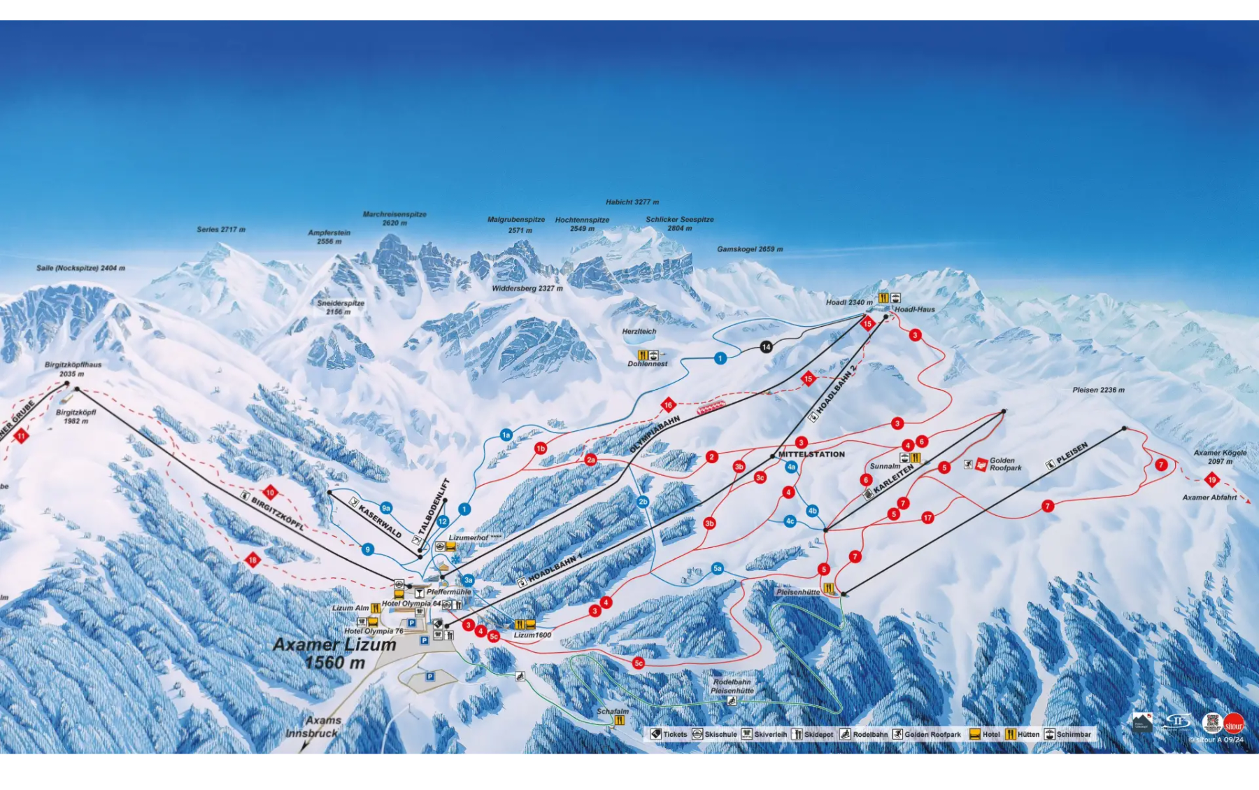
Explore Axamer Lizum's full trail map with 24 runs across the mountain, colour-coded by difficulty and shown alongside the terrain split. Use it to plan a day that matches your ability, find lift-served pockets of your favourite grade, and see how the resort links together. Download the piste map (PDF) ↗
More Axamer Lizum intelligence: snow report, lift system, webcams, resort overview.