
Hochkönig
1,100m vertical, 120km of runs, 34 lifts. Legendary Königstour ski circuit. Part of Ski amadé. Maria Alm, Dienten and Mühlbach, Salzburg, Austria.
Season 2026 - 2027
Opens
5 Dec 2026
Closes
4 Apr 2027
Days open
120
Annual snow
2m
The Overview
Michael Fulton
Melbourne-based skier and snowboarder with 50+ resorts across 5 continents. Specialises in Australian resorts and international resort comparisons.
Hochkönig operates between 800 and 1,900 metres, delivering 120 kilometres of marked piste across a vertical drop of 1,100 metres — one of the largest self-contained ski areas in the Salzburg region. The legendary Königstour ski circuit links six peaks and 35 kilometres of continuous downhill skiing in a single day, recognised as one of the best ski circuits in the Alps since its launch in 2012. Eight additional kilometres of marked ski routes extend the off-piste offering for confident skiers. The resort is part of the Ski amadé network, giving pass holders access to 760 kilometres of pistes across five Salzburg ski regions on multi-day tickets.
Terrain divides into 43% beginner, 34% intermediate and 23% advanced across 63 marked runs, with the longest single descent stretching 9 kilometres. Wide, perfectly groomed carving slopes through larch forest dominate the mid-mountain, whilst the 1-kilometre Hochmaist descent provides the steepest challenge. The Blue Tomato Kings Park at Aberg features tables, rails and kickers for freestyle riders, complemented by the Funslope Schönanger with its Skimovie speed-tracking run and the dedicated Family Run for progressing skiers. Extensive freeride terrain above the treeline rewards powder hunters after fresh snowfall on the north-facing Hochkönig slopes.
Maria Alm retains an authentic Salzburger Land village character with a baroque parish church, timber-clad farmhouses and a pace of life that reflects a genuine local community rather than a purpose-built resort. Over 30 traditional mountain huts serve regional Salzburg cuisine across the ski area, and the Culinary Königstour route combines skiing with curated gastronomic stops at selected huts. Beginner areas at Natrun, Hintermoos and the village nursery slopes allow first-timers to learn independently from the main gondola network, whilst the Marlies Schild training course offers structured improvement for developing intermediates.
Adult day passes start from €73 in shoulder season and €78.50 during peak weeks, with children (6-15) paying €36.50 to €39.50 and youth €55 to €59. Prices shown are based on the most recently published 2025-26 rates; 2026-27 pricing uses Ski amadé dynamic online pricing and will be confirmed ahead of the season opening. Children born 2021 or later ski free with a Minicard when accompanied by an adult. The resort suits families and intermediates seeking wide, well-groomed terrain with genuine Alpine village atmosphere, whilst advanced skiers will find enough challenge on the Hochmaist, Wastlhöhe mogul slope and the Königstour's varied descent profiles.
1100m
Vertical
63
Runs
120 km
Piste
2m
Annual snow
Ski Amadé
Pass
The Terrain
63 runs across 120 km of piste
Hochkönig spreads 120 kilometres of piste across 63 runs and 1,100 metres of vertical, from 800 to 1,900 metres, and the terrain leans towards easy skiing: beginners take 43%, intermediates 34% and advanced skiers 23%. The slopes are split across five main sectors, Natrun, Aberg-Langeck, Gabühel, Wastlhöhe and Schneeberg, linked by wide groomed runs that often pass through forest. That makes it a mountain of long, flowing cruising rather than technical pitches, which suits families and mixed-ability groups well.
Stronger skiers still have options, with black slopes on Aberg-Langeck, Gabühel, Wastlhöhe and Schneeberg, and the Hochmaist descent, at about a kilometre, the steepest challenge on the mountain. Valley run number 1 is also graded black, though it runs through forest down to Mühlbach and makes a satisfying end to the day for confident skiers. The Königstour ties six peaks into a 35-kilometre circuit, a full day's skiing best suited to intermediates and above who want to cover the whole area in one go.
Terrain split
63
runs
63 runs across 4 grades
Beginner27 runs · 43%
Intermediate21 runs · 34%
Advanced14 runs · 23%
Expert0 runs · 0%
Time it right
When to visit Hochkönig
The 2026-27 season is scheduled to run from 5 December 2026 to 4 April 2027, with operating hours from 08:30 to 16:00 daily. The resort traditionally opens the first weekend of December with shoulder-season pricing through mid-December, before peak rates apply from late December through early April. Hochkönig's north-facing aspects and extensive snowmaking — covering the majority of the key piste network — deliver reliable conditions from opening day through the spring closure, making it one of the more snow-sure non-glacier areas in the Salzburg region.
Annual snowfall averages 172 centimetres at resort level, with substantially more accumulation on the upper slopes above 1,600 metres where north-facing terrain retains snow well into April. December typically delivers the heaviest monthly totals, followed by consistent accumulation through January and February. Comprehensive snowmaking installations with reservoirs and modern piste-grooming equipment ensure groomed conditions across the key runs even during natural snow gaps, supporting the resort's reputation as one of the most reliable ski areas in the Pongau district.
Early December offers the best value with shoulder-season pricing and quiet slopes as the full 120-kilometre network opens progressively. Christmas and New Year bring peak-season crowds but also the fullest hut and event programme across all three villages. January and February deliver the coldest temperatures and best powder conditions on the Königstour's upper slopes and freeride routes. March is the sweet spot for many regulars: long sunny days, firm morning corduroy on the wide pistes and soft afternoon snow, with the full circuit typically operational through to the April closing weekend.
The Ski Challenge Hochkönig race series runs throughout the season for recreational competitors, whilst the Culinary Königstour combines the classic ski circuit with stops at selected mountain huts serving regional specialities. Night skiing on the floodlit Natrun slopes in Maria Alm extends the ski day into the evening on selected dates. Spring skiing on the upper Aberg and Hochmais terrain remains possible through the scheduled 4 April closing date, with end-of-season events in the villages of Maria Alm, Dienten and Mühlbach marking the transition to summer hiking season on the Königweg long-distance trail.
Season 2026 - 2027
5 Dec 2026
Opens
4 Apr 2027
Closes
120
Days open
2 m
Annual snow
Getting there
Getting to Hochkönig, and where to stay
The Hochkönig ski region sprawls across the northern flanks of the Hochkönig massif in Salzburg's Pongau district, connecting the traditional Alpine villages of Maria Alm am Steinernen Meer, Dienten am Hochkönig and Mühlbach am Hochkönig beneath peaks rising to 2,941 metres. The name Steinernes Meer — the Stone Sea — refers to the dramatic limestone karst plateau of the Berchtesgaden Alps that forms the backdrop to every run. The ski area itself reaches 1,900 metres at the Aberg summit station, with the Hochkönig peak towering a further 1,000 metres above the highest lift-served terrain.
Maria Alm sits at 800 metres as the largest base village, with satellite hamlets at Hintermoos, Hinterthal and Aberg connected by lift and ski bus. Dienten lies 8 kilometres west at the foot of the Hochkönig's western ridge, whilst Mühlbach occupies the eastern approach at 860 metres with a rich copper-mining heritage dating to prehistoric times. Saalfelden am Steinernen Meer, the nearest town with full services, lies 6 kilometres north. The region forms one of five sectors within the Ski amadé mega-pass, alongside Salzburger Sportwelt, Schladming-Dachstein, Gastein and Großarltal.
Salzburg Airport (SZG) lies 60 kilometres northeast and approximately one hour by road via the A10 and B164 Hochkönigstraße. Munich Airport is 180 kilometres northwest via the A8 and A10, around two hours in normal conditions. Innsbruck Airport sits 150 kilometres southwest via the Felbertauern tunnel route, useful for arrivals from western Austria and Switzerland.
Bischofshofen Hauptbahnhof on the Salzburg–Villach main line lies 13 kilometres east, with regular ÖBB rail connections from Salzburg (45 minutes), Vienna (2.5 hours) and Munich (2 hours). Postbus line 620 links Bischofshofen to Maria Alm, Dienten and Mühlbach on a regular winter timetable. Free ski buses operate between all Hochkönig villages throughout the season for lift pass holders, making car-free access practical from any base village. The B164 Hochkönigstraße provides the main road access from Bischofshofen through the valley.
Where to stay
Search all stays →Hotels and lodges near Hochkönig, powered by Stay22.
Latest News
From the SnowStash desk

Europe Ski Resorts Open Now: What Is Skiable in Mid-October 2026
Europe’s ski season is open, technically. After a record-warm summer, glaciers in Austria, Switzerland and Italy are running a few pistes apiece, Sölden, Stubai and Kitzsteinhorn started late, Titlis has pushed back to 24 October, and Zermatt reopens a few lifts on 14 October after more than two months shut. Finland’s Levi and Ruka are skiing on stored snow. Here is what is open, and what you actually get at each.
14 Oct 2026

Zermatt Plans World Cup Downhill Return on the Gornergrat for 2028
Zermatt is having another crack at a World Cup downhill, and this time nobody has to cross a border. Around 13 million Swiss francs is going into rebuilding the Gornergrat piste, including a jump fed by a roughly 300-metre in-run across the roof of the Gornergrat Railway gallery, with the Matterhorn lined up behind it for the TV cameras. First men’s race is pencilled in for March 2028, pending FIS homologation.
14 Oct 2026

Mt. Rose Begins Snowmaking for the 2026-27 Season at Lake Tahoe
Lake Tahoe’s highest base elevation is paying off early: Mt. Rose has started making snow for 2026-27 after the first flurries and a cold snap. The Nevada resort is backing it with nearly US$2 million in upgrades, including a replacement snowmaking main line, a new PistenBully groomer and restraint bars on every lift. Opening day is yet to be confirmed, though Heavenly and Northstar are already eyeing 20 November.
13 Oct 2026

Utah Ski Resorts 2026-27: What’s New at Alta, Deer Valley, Powder Mountain and More
Utah is still building flat out. For 2026-27, Powder Mountain opens a steep new Skytrac chair into more than 1,000 acres of advanced terrain, Deer Valley adds 200 acres on Hail Peak, Sundance gets a new quad and Park City adds a gondola from its new parking structure. Snowmaking is expanding almost everywhere, Eagle Point stays closed after the Cottonwood Fire, and the 2034 Games are setting the pace. Here’s what’s new, resort by resort.
13 Oct 2026

Mt Hutt Invests NZ$12 Million in Base Area, Tripling Its Sun Deck
Mt Hutt is getting busier, and its base lodge is about to catch up. NZ$12 million goes into a heated sun deck roughly three times the current size (430 m² to 1,300 m²), plus a new toilet block, heated steps down to snow level, extra storage and a new food and beverage outlet. Building starts after the 2026 season, with everything due for winter 2027.
11 Oct 2026

Vermont Ski Resort Opening Dates 2026-27: Few Dates Set, Killington Waits on the Cold
Vermont's season is slow to take shape. Stratton is tentatively targeting 18 November and Sugarbush 21 November, while Pico has Friday 11 December on the calendar. Killington never sets a date and opens when the snowmaking allows, and Vail Resorts has yet to name days for Stowe, Okemo and Mount Snow. The forecasts disagree about snow, and the main El Niño worry for the Green Mountains is warmth.
9 Oct 2026
Crans-Montana 2027 World Championships President Resigns Ahead of Fraud Hearing
Less than four months out from the Crans-Montana 2027 World Championships, the man running the organising committee has stepped down. Claude-Alain Schmidhalter resigned as Swiss-Ski vice president and OC president after being indicted over a business dispute unrelated to skiing. He denies the allegations and faces court on October 27. Interim leaders are in place for the February 1-14 event.
9 Oct 2026
Kelly Canyon, Idaho, Adds Snowmaking, a Bigger Terrain Park and More Parking for 2026-27
Kelly Canyon had a rough 2025-26, and the Idaho resort has spent the summer making sure it doesn’t repeat. Snowmaking now reaches the top of Goldrush, the terrain park is doubling in size with a stereo system, lights and a snack shack, and the car park is getting bigger. Grooming is stepping up too. Target opening is December 4, conditions permitting.
9 Oct 2026
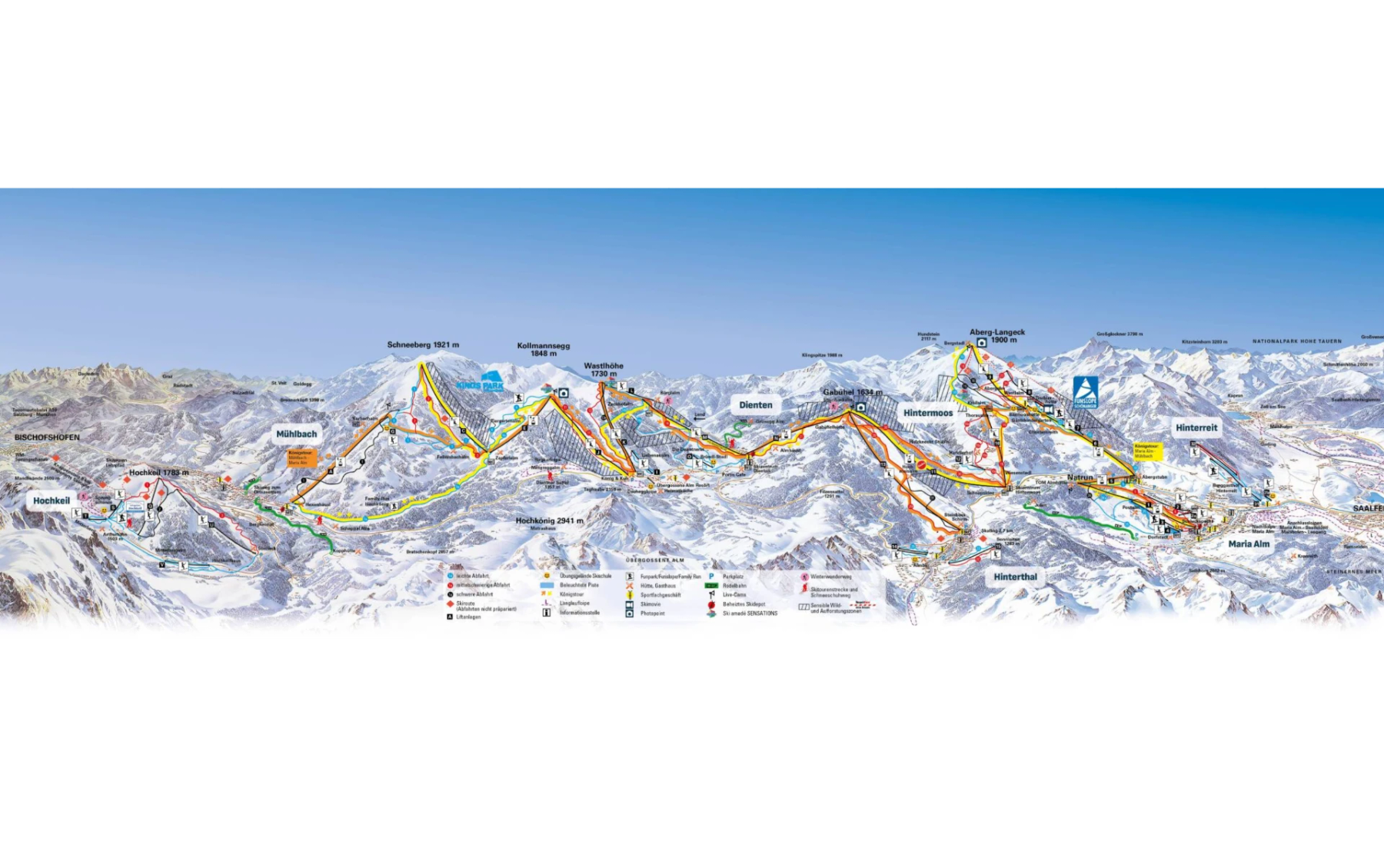
Hochkönig Trail Map
Downloadable Hochkönig trail map
Terrain split
63
runs
Beginner43%
Intermediate34%
Advanced23%
Expert0%
120 km of piste
Resort Stats
Elevation
Base800m
Summit1900m
Annual snowfall
2m
Season
2026 - 2027
5 Dec 2026 - 4 Apr 2027
Trail coverage
63 runs
120 km
About Hochkönig's trail map
Explore Hochkönig's full trail map with 63 runs across the mountain, colour-coded by difficulty and shown alongside the terrain split. Use it to plan a day that matches your ability, find lift-served pockets of your favourite grade, and see how the resort links together. Download the piste map (PDF) ↗
More Hochkönig intelligence: snow report, lift system, webcams, resort overview.