SnowStash
ForecastsCompareNews
SnowStash Logo

Live snow, webcams and expert resort guides for the world's mountains - plan your next day on snow.

hello@snowstash.com
Download on the App StoreGet it on Google Play

Destinations

  • Australia
  • Canada
  • Europe
  • Japan
  • New Zealand
  • United States

Company

  • About Us
  • Work With Us
  • Privacy Policy

Explore

  • Compare Resorts
  • News & Updates
  • Snow Forecast
  • Mobile App

© 2026 SnowStash. All rights reserved.

    1. Home
    2. /
    3. News
    EuropeFranceSwitzerlandAustriaItaly

    Alps Snow Forecast: Up to 64 cm Headed for the High Glaciers as the Snow Line Drops

    Michael FultonMichael Fulton·20 Oct 2026

    TL;DR

    The Alps are about to swap mild, sunny October weather for something far more wintry. A cold front arrives Tuesday, and SnowStash forecasts have Monterosa Ski out in front with 64 cm over 14 days, ahead of Blatten Belalp (55 cm) and Verbier (43 cm). The snow line should fall below 2000 metres by Wednesday night, and glaciers across Switzerland, Italy and Austria are in line for the best of it. The wind will have a say too.

    Read in the app

    Ski news, snow reports and resort intel in one place.

    Download on the App StoreGet it on Google Play

    Read in the app

    Ski news, snow reports and resort intel in one place.

    Download on the App StoreGet it on Google Play

    Get SnowStash in your Google feed

    Follow us as a preferred source so our stories show up more in Search.

    Advertisement

    The Alps have spent most of October under mild, sunny skies, and that changes on Tuesday.

    A cold front moving in from the west will push the snow line down over the next few days. SnowStash forecasts put the biggest totals on the high glaciers of Switzerland and Italy. Monterosa Ski in Italy leads our leaderboard with 64 cm over the next 14 days, and most of it arrives in the first two days.

    Where the snow is forecast to fall

    Monterosa Ski (3275 m) is forecast to pick up 28 cm on Tuesday 20 October and 26 cm on Wednesday 21 October. A light 1 cm follows on Friday and a further 9 cm on Sunday 25 October, before it dries out on Monday.

    Blatten Belalp in Switzerland (3118 m) sits second on 55 cm. Wednesday carries 26 cm of that, with another 13 cm on Sunday. Verbier 4 Vallées (3300 m) is third on 43 cm, including 23 cm on Wednesday.
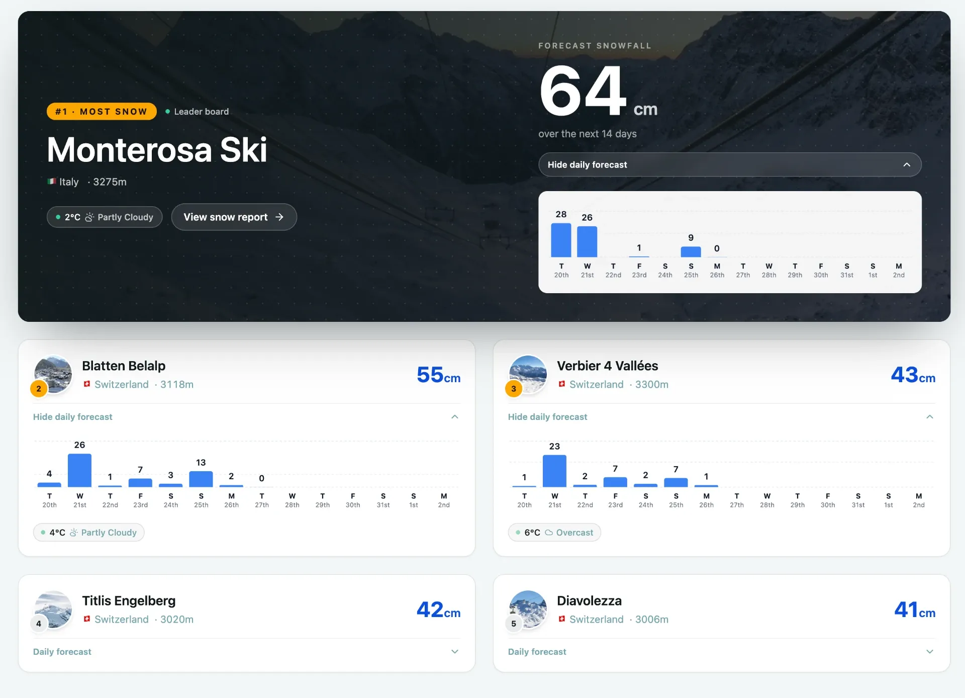
    The top 5 resorts in Europe according to our forecasts
    The top 5 resorts in Europe according to our forecasts
    Advertisement

    The rest of the top 11:

    • Titlis Engelberg, Switzerland (3020 m): 42 cm
    • Diavolezza, Switzerland (3006 m): 41 cm
    • Corvatsch, Switzerland (3303 m): 38 cm
    • Leukerbad, Switzerland (2610 m): 36 cm
    Advertisement
    • Val d’Isère, France: 36 cm
    • Pitztal Glacier, Austria (3440 m): 35 cm
    • Glacier 3000, Switzerland (3016 m): 35 cm
    • Schnalstal Glacier, Italy (3212 m): 30 cm

    These are upper-mountain totals across the full 14-day window, and a fair chunk of it falls after the front has passed. SnowStash forecasts are deliberately conservative, so you will see bigger numbers on some other models. We would rather under-promise on a number than have you plan a trip around a figure that does not show up.

    Advertisement

    Austria gets its turn on Wednesday

    Western Alps resorts get the first hit, but this front does not stop at the Swiss border. GeoSphere Austria expects a cold front to cross from the west on Wednesday, bringing precipitation to the northern and central ranges. It forecasts 0 to 30 cm locally in the eastern Alps, with glaciers best placed to hold the new snow.

    Pitztal Glacier is our highest-ranked Austrian entry on 35 cm. Glacier skiing in Austria is already under way for the season, so extra natural snow is welcome, wind permitting.

    The rest of the top 11 resorts in our forecasts
    The rest of the top 11 resorts in our forecasts.
    Advertisement

    Snow line and wind

    Tuesday will be a rain-or-snow story depending on height. The snow line starts around 3000 m, so most precipitation below that falls as rain, and only the highest peaks and glaciers turn properly wintry. Conditions are mild going in, with freezing levels between 3000 and 3700 m across much of Austria on Monday.

    Colder air arrives from the west through Wednesday. GeoSphere Austria says the snow line on the northern side of the Alps could drop below 2000 m by Wednesday evening. Overnight into Thursday, snow below 1500 m is possible locally. That does not mean every village above that height wakes up white. The line shifts from region to region, and precipitation can ease just as the coldest air arrives.

    Wind is the other factor. A strong foehn blows on the northern side ahead of the front, and GeoSphere Austria expects gusts of up to 120 km/h at around 3000 m in the eastern Alps on Wednesday. The highest peaks in the western Alps can also expect severe gusts. Glacier lifts can close temporarily in that combination of wind, poor visibility and fresh snow, so check the lift status and forecast before heading up.

    The Dolomites mostly get rain

    Advertisement

    Northern Italy is in for a wet Wednesday. Meteo Trentino has warned of potentially large precipitation totals between Tuesday evening and Thursday morning. GeoSphere Austria also expects plenty of precipitation from the Sexten Dolomites eastward.

    The snow line starts high there, so most of it falls as rain at lower elevations, with a fresh layer only on the highest summits. Models show smaller amounts for Cortina d’Ampezzo and Val Gardena than for the western Alps.

    After Thursday

    Thursday looks calmer, with the precipitation clearing and sun breaking through in many places. That should make for decent webcam images on the glaciers and highest summits where the new snow has settled.

    The quiet does not last. Another disturbance is showing for Friday 23 and Saturday 24 October, mostly affecting France and Italy, with snow possible from around 1600 to 2000 m. Reliability is limited at this range. Blatten Belalp and Verbier each have 7 cm pencilled in for Friday in our data, and both come back for more on Sunday, with 13 cm and 7 cm respectively.

    About the author

    Michael Fulton

    Michael Fulton

    Melbourne-based skier and snowboarder with 50+ resorts across 5 continents. Specialises in Australian resorts and international resort comparisons.
    50+ resorts visited15 years skiing
    Advertisement

    Keep reading

    More from the SnowStash desk

    View all news →
    Val Gardena to Alpe di Siusi Lift Link Back in Play After Court Ruling

    Val Gardena to Alpe di Siusi Lift Link Back in Play After Court Ruling

    The Val Gardena-Alpe di Siusi lift link isn’t dead after all. A South Tyrol court has overturned Santa Cristina’s rejection of the new Monte Pana-Saltria link on procedural grounds, after the council skipped required public information sessions. Opponents want the missing sessions held and a fresh vote, and nothing has been approved. For now it’s still a bus between the two, but a plan first floated in 2017 is back in the conversation.

    8 Nov 2026
    Whistler Blackcomb Rockslide Zone Stays Closed Through 2026-27 Season

    Whistler Blackcomb Rockslide Zone Stays Closed Through 2026-27 Season

    A section of Whistler Peak terrain will stay closed all 2026-27 season, Vail Resorts has confirmed, with rockslide mitigation work continuing into summer 2027. Peak Express is still expected to run this winter, but locals are already arguing about what’s actually off limits, whether the Whistler Bowl is gone, and why the news landed after pass sales wound down. Here’s where things stand.

    7 Nov 2026
    Loveland Ski Area Opens for 2026-27 and Marks 60 Years of Snowmaking

    Loveland Ski Area Opens for 2026-27 and Marks 60 Years of Snowmaking

    Loveland is open. The Colorado ski area started Chet’s Dream turning on Saturday 7 November to kick off 2026-27, with $60 adult lift tickets to mark 60 years of snowmaking. Expect three runs, nearly 1,000 vertical feet (about 300 metres) of top-to-bottom skiing, live music on the Basin Patio and no beginner terrain yet. Here’s what’s open, what it costs and when Loveland Valley follows.

    7 Nov 2026
    KFC Is Coming to the Slopes at Cortina and Madonna di Campiglio

    KFC Is Coming to the Slopes at Cortina and Madonna di Campiglio

    Fried chicken is heading up the Dolomites. From 5 December KFC will run two restaurants on the slopes - one at 2,123 metres at Cortina, one at 1,700 metres at Madonna di Campiglio - and the polenta-and-canederli crowd has opinions. Local politicians, conservation groups and plenty of Facebook commenters are calling it a step too far, while others just want a cheaper lunch. Here’s what’s on the menu and what’s the fuss.

    5 Nov 2026
    Mt Rose Aims to Open First in Tahoe on November 6

    Mt Rose Aims to Open First in Tahoe on November 6

    Mt Rose is going for the first-in-Tahoe title, with the Lakeview Express due to spin at 9 a.m. on Friday, November 6. One main lift, three runs and plenty of snowmaking, sitting on the highest base elevation in the region at 8,260 ft. Here is what is open, what is not (sorry, tubing fans), and how the early North American openings are stacking up.

    4 Nov 2026
    Europe Snow Forecast: Serre Chevalier Leads With 82 cm Over the Next 10 Days

    Europe Snow Forecast: Serre Chevalier Leads With 82 cm Over the Next 10 Days

    Europe has had a quiet start to November, but our 10-day forecast has Serre Chevalier on 82 cm and Les 2 Alpes on 71 cm. Two pushes are lined up: a western Alps top-up from Friday, then a bigger, wider system on Thursday, November 12 and Friday, November 13 that reaches Italy and Switzerland. Full leaderboard inside.

    4 Nov 2026
    Mammoth Mountain Opens Early on November 5 With Up to 33 Inches of Snow in the Forecast

    Mammoth Mountain Opens Early on November 5 With Up to 33 Inches of Snow in the Forecast

    Mammoth just moved opening day forward to Thursday, November 5, eight days ahead of schedule. A snowy weekend and cold snowmaking nights did the work, and our forecast shows up to 33 inches more landing on November 13 and 14. Here is what opens, what the weather looks like and where Mammoth sits among the early Ikon Pass openers.

    3 Nov 2026
    Utah Snow Storm Builds Early-Season Base Ahead of November Openings

    Utah Snow Storm Builds Early-Season Base Ahead of November Openings

    Rain down low, snow up high, and a snow report full of zeros that mostly means ‘not updated yet’. Utah’s first proper storm of 2026-27 is rolling through the Wasatch, Snowbird’s snow stake is closing in on 10 inches, and Brian Head is five days from opening day. Early November snow rarely looks like much, but it is the layer every November opening date is built on. Here is where it stands.

    1 Nov 2026