

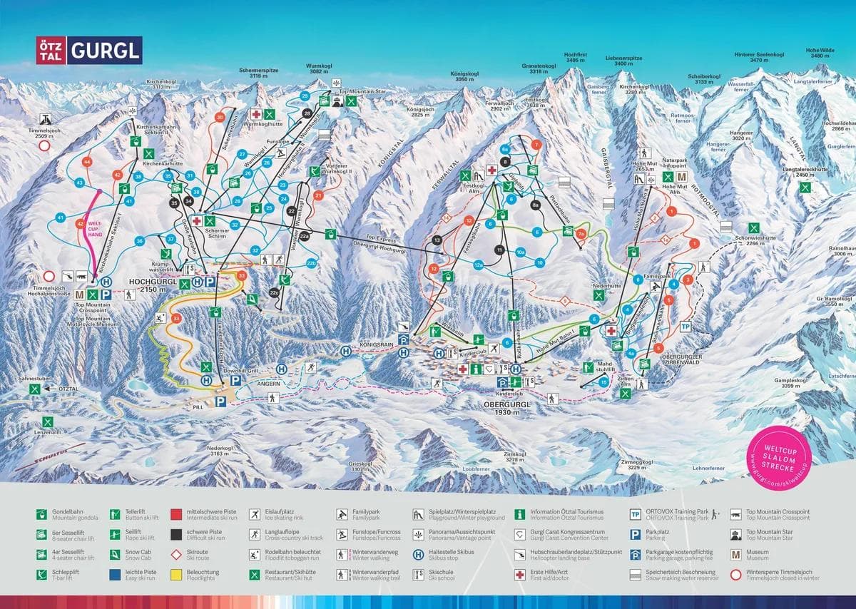
Note: European resorts use Blue for beginner and Red for intermediate runs
🚡 Chairlifts: Main mountain access
🔄 Gondolas: Enclosed cabin transport
🎿 Ski Runs: Marked trails with difficulty ratings
🏠 Facilities: Lodges, restaurants, and services
💡 Pro Tip: Start with green runs to warm up
Total Runs
50
Total Area
112km
69.6 miles
Obergurgl-Hochgurgl features 50 ski runs covering 112 kilometers of terrain. The Obergurgl-Hochgurgl trail map shows runs for all skill levels from beginner green runs to expert black diamond trails.
Yes! The Obergurgl-Hochgurgl trail map is available for download as a PDF file. Look for the download button on the trail map image above. This Obergurgl-Hochgurgl piste map can be saved to your phone or printed for easy reference while skiing.
The Obergurgl-Hochgurgl trail map uses standard ski run difficulty ratings: Blue for beginner runs, Red for intermediate, Black for advanced, and Black for expert terrain. This Obergurgl-Hochgurgl ski map color coding helps you choose appropriate trails for your skill level.
Beginner skiers should look for green runs on the Obergurgl-Hochgurgl trail map, typically located near the base area and served by beginner-friendly lifts. The Obergurgl-Hochgurgl ski map shows these gentle slopes perfect for learning and building confidence.
Use the Obergurgl-Hochgurgl trail map to identify blue and red runs that connect directly to the base area. Look for trails marked as “direct routes” or “main runs” on the Obergurgl-Hochgurgl piste map. These typically offer the most efficient descent from the summit.
The Obergurgl-Hochgurgl trail map shows all official marked ski runs and maintained trails. However, some advanced skiers may discover unofficial routes between marked trails. Always check the Obergurgl-Hochgurglski map for current trail status and closures before exploring.
The Obergurgl-Hochgurgl trail map is updated seasonally to reflect any new trails, lift changes, or facility additions. For real-time trail conditions and closures, check the current snow report alongside the Obergurgl-Hochgurgl piste map.
Absolutely! The Obergurgl-Hochgurgl trail map is fully mobile-optimized. You can view the interactive Obergurgl-Hochgurglski map on your smartphone or tablet, and download the PDF version for offline use. This makes theObergurgl-Hochgurgl trail map perfect for on-mountain navigation.
Elevation
Base
1793m
Summit
3030m
Annual Snowfall
4.5m
Season
2025-2026
11/20/2025 - 4/19/2026
Trail Coverage
50 Runs
112 km

Jul 19, 2026

Jul 18, 2026

Jul 17, 2026

Jul 16, 2026
Jul 15, 2026
